TOPP-The Optimal Path Program
This program finds the least cost path using a DEM (Digital Elevation Model) image. Program converts DEM to slope first and then outputs the path in raster format. The path can be converted to vector (shapefile) format with this program.
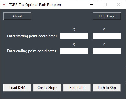
Inputs for the program
Input parameters are a cost surface raster (e.g. slope) and start and stop coordinates. You can download DEM files from asf.alaska.edu orearthexplorer.usgs.gov
How to run the program
Launch the TOPP and then copy and paste the coordinates of start and destination points to the textboxes in the program. Click Load DEM button and select the DEM file. Then click Create Slope button which creates slope from the DEM. Click Find Path button that finds the least cost path in a raster file. Finally, click Path to Shp button in order to convert raster file to line vector file (ESRI shapefile).